 Home Page
Canada Trip
—Click any tiny picture for a larger pop-up image gallery with left/right arrows; [X] to shut images down—
 May 2013: The main reason for going to Canada was to attend Eric’s wedding, and that was held at Lake Muskoka, north-west of Toronto where he lives. Apart from visiting Toronto, Eric had booked me to fly to Calgary in Alberta – at the western edge of the plains and the eastern edge of the Canadian Rockies – and to travel the Rocky Mountaineer train from Banff to Vancouver before flying home again.
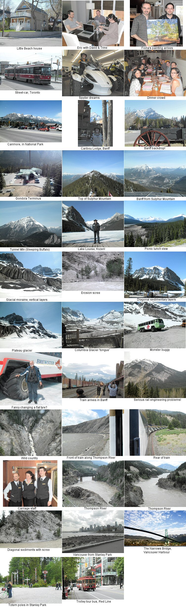 May 2023: To save Server space, ten years down the track, I have now replaced all the photos on this page with one large image. Click the small image (right) to enlarge, [X] to close.
Wednesday May 1: My trip started at 3am, loading the Noddy Car with my luggage, driving to Graham’s place and then down to Brisbane for my 5am check-in. Graham would park my car at his Shorncliffe house while I was away. Fiona had sent me a painting for Eric that I took with me as an extra luggage item, marked Fragile, of course! A Qantas flight to Sydney, then a transfer to the International Airport followed, and the flight to Vancouver lifted off on schedule at 10am. The flight takes about 15-16 hours, but Vancouver is 17 hours behind AEST and we had favourable winds, so I landed in Vancouver at 8am Wednesday morning – 2 hours before I took off from Sydney! Fiona’s Fragile package came into play then... they are handled separately. So I was sent up to a different floor to collect that manually ( my main bag was tagged for Toronto anyway ), there to be told that I should proceed immediately to my connecting flight to Toronto, so I never actually went through Customs at all. Not quite sure why, but I then flew to Toronto, which is 3 hours ahead of Vancouver, so landed there in the late afternoon despite the flight being only 4 hours.
[Images: Little Beach House, Eric with David & Trine, Fiona’s painting arrives, Street-car in Toronto.]
I broke my bag-handle at the airport – it just pulled right out! Eric and Terry met me there and we went to their house in Little Beach, Toronto, where I met David & Katrina Peers, who had flown in from Sydney several days earlier and were heavily involved in the wedding planning. David was to be Best Man, and Trine was organizing the reception. The last time I met them was when I was in Liverpool Hospital with broken fingers, toes, shoulder and covered in technicolor bruises, after my somewhat truncated trip to Tassie with the bike club a few years back – they observed that, despite the jet-lag and tiredness ( after 21 hours in the air plus 6 hours airport waiting ), I was in much better shape now than then! After I had handed over the various gifts that I had brought with me, including that awkward-sized painting, Eric dropped me off at a small hotel near his house for the first 2 nights. Toronto still has Street-cars ( trams ), I noticed, so their tracks would make bike-riding awkward, and Eric commented that they also cause peak-hour traffic backups and delays because they stop in the middle of the road... traffic can’t pass while they are stopped.
I broke my bag-handle at the airport – it just pulled right out! Eric and Terry met me there and we went to their house in Little Beach, Toronto, where I met David & Katrina Peers, who had flown in from Sydney several days earlier and were heavily involved in the wedding planning. David was to be Best Man, and Trine was organizing the reception. The last time I met them was when I was in Liverpool Hospital with broken fingers, toes, shoulder and covered in technicolor bruises, after my somewhat truncated trip to Tassie with the bike club a few years back – they observed that, despite the jet-lag and tiredness ( after 21 hours in the air plus 6 hours airport waiting ), I was in much better shape now than then! After I had handed over the various gifts that I had brought with me, including that awkward-sized painting, Eric dropped me off at a small hotel near his house for the first 2 nights. Toronto still has Street-cars ( trams ), I noticed, so their tracks would make bike-riding awkward, and Eric commented that they also cause peak-hour traffic backups and delays because they stop in the middle of the road... traffic can’t pass while they are stopped.
Thursday May 2: [Images: Spyder dreams, Dinner crowd.]
Spring had sprung in Toronto with a vengeance! Only the week before the whole city had been knee-deep in snow, but torrential rain had turned it all to slush and caused widespread flooding, then the sun came out just before I arrived. The first green buds and shoots were showing on trees that had been no more than bare, woody skeletons just a day or so before. There had been talk of visiting Niagara Falls that day but the weather was still not great down there and Eric & Terry had some last-minute shopping to do, plus I wanted to buy a replacement bag, so we went to Plan B. This included taking me to the local BRP Dealer to see the new ST model Spyder, because that would be a quick visit, and I could buy a new suitcase while Eric & Terry did their own shopping. That all went off very well, and we got back to Little Beach in the late afternoon. A dinner had been arranged at a downtown Italian Restaurant that night, so I went with other guests to that, but had an unfortunate dental break before the meal, so could not eat. What timing! Oh, well, it’s soup for me for a few days until I have the time to get that fixed. Back to the hotel for a welcome night’s sleep.
Spring had sprung in Toronto with a vengeance! Only the week before the whole city had been knee-deep in snow, but torrential rain had turned it all to slush and caused widespread flooding, then the sun came out just before I arrived. The first green buds and shoots were showing on trees that had been no more than bare, woody skeletons just a day or so before. There had been talk of visiting Niagara Falls that day but the weather was still not great down there and Eric & Terry had some last-minute shopping to do, plus I wanted to buy a replacement bag, so we went to Plan B. This included taking me to the local BRP Dealer to see the new ST model Spyder, because that would be a quick visit, and I could buy a new suitcase while Eric & Terry did their own shopping. That all went off very well, and we got back to Little Beach in the late afternoon. A dinner had been arranged at a downtown Italian Restaurant that night, so I went with other guests to that, but had an unfortunate dental break before the meal, so could not eat. What timing! Oh, well, it’s soup for me for a few days until I have the time to get that fixed. Back to the hotel for a welcome night’s sleep.
Friday May 3: Back to Little Beach because Eric had hired 2 minivans with seats for 6 and luggage storage at the back. We needed every last seat, and the luggage was shoehorned into place! Guests had started to arrive from Australia and the UK, plus Virginia ( Best Woman ) also needed transport. After complex luggage arrangements we got underway to Lake Muskoka. There is a separate page about the actual wedding weekend here, covering Saturday May 4 & Sunday May 5.
Monday May 6: Because Eric & Terry were flying out for their honeymoon trip to Mexico at roughly the same time as I would be flying out to Calgary in Alberta, they had arranged to collect me from the hotel on the way, but I slept in! I had set the alarm but failed to arm it, so it just didn’t go off. Eric had the desk call me on the phone, so I was out of bed and packed in record time – then it was out to the airport where I was able to farewell ‘Ez & Tez’ ( as they were referred to during the wedding reception ), then board my own flight to Calgary. At the airport, I caught a shuttle bus to Banff but was the only passenger – weird! On the outskirts of Calgary the driver invited me to sit up front beside him so he would not have to use the PA system for his usual running commentary on sights of interest. It’s about a 3-hour drive from Calgary to Banff, which is well inside the Banff National Park. At the entrance to the Park, in the Bow River Valley ( after the local Indians used to find good wood for making bows there ) there is a town called Canmore, and that is about 20 minutes by shuttle-bus from Banff. This proved to be important the next day. Eric had looked up dentists in Banff so I called the one-and-only as soon as I had checked into the Banff Caribou Lodge, to be told that only simple toothache-style work could be handled in Banff itself, but I was referred to a specialist in Canmore. They were able to make an appointment for me for the following morning.
Tuesday May 7: [Images: Canmore, just inside the National Park, Outside Caribou Lodge, Banff, Banff backdrop!]
Caught the shuttle-bus to Canmore, noting that they demand exact change ( $6 each way ) but also provide a payment machine that accepts notes as well as coins... I saw several passengers get on and shove a $10 note into the machine then ask the driver why they didn’t get any change – it doesn’t make change. The machine bing-bongs when it receives ENOUGH money, but the fare is basically whatever you shove into the machine, so long as it’s at least $6! ( I’d like to believe that what is left over goes toward the NEXT passenger’s fare, but I think that I’m being a bit optimistic. ) Anyway, I made a mental note to be sure that I had $6 in coins before heading back to Banff! I found the dentist, who was very helpful and fixed me up efficiently – now I will be able to eat normally again. However the shuttle bus service pauses during the middle of the day so I walked around Canmore for a few hours before catching the bus back to Banff in the afternoon. I found out that Banff had been developed under a strict government leasehold arrangement – nobody owns land in Banff; it’s all leased from the government, who simply doesn’t grant leasehold unless the land is needed for direct tourist business-related purposes. The scheme is to ensure that Banff remains the tourist center for the Rockies, and does not start to sprawl. It has to stay pristine and tidy, easy for tourists to use. The only residential buildings are for senior management of important local businesses. All other staff commute from Canmore every day, so Banff is all Hotels, Resorts, restaurants, souvenir shops, entertainment, etc... and absolutely nothing else. Canmore benefits, too – they provide all the service- and residential-based facilities, but all out of sight of tourists wandering around sparkling Banff.
Caught the shuttle-bus to Canmore, noting that they demand exact change ( $6 each way ) but also provide a payment machine that accepts notes as well as coins... I saw several passengers get on and shove a $10 note into the machine then ask the driver why they didn’t get any change – it doesn’t make change. The machine bing-bongs when it receives ENOUGH money, but the fare is basically whatever you shove into the machine, so long as it’s at least $6! ( I’d like to believe that what is left over goes toward the NEXT passenger’s fare, but I think that I’m being a bit optimistic. ) Anyway, I made a mental note to be sure that I had $6 in coins before heading back to Banff! I found the dentist, who was very helpful and fixed me up efficiently – now I will be able to eat normally again. However the shuttle bus service pauses during the middle of the day so I walked around Canmore for a few hours before catching the bus back to Banff in the afternoon. I found out that Banff had been developed under a strict government leasehold arrangement – nobody owns land in Banff; it’s all leased from the government, who simply doesn’t grant leasehold unless the land is needed for direct tourist business-related purposes. The scheme is to ensure that Banff remains the tourist center for the Rockies, and does not start to sprawl. It has to stay pristine and tidy, easy for tourists to use. The only residential buildings are for senior management of important local businesses. All other staff commute from Canmore every day, so Banff is all Hotels, Resorts, restaurants, souvenir shops, entertainment, etc... and absolutely nothing else. Canmore benefits, too – they provide all the service- and residential-based facilities, but all out of sight of tourists wandering around sparkling Banff.
Wednesday May 8: [Images: Gondola Terminus, Top of Sulphur Mountain, Banff from Sulphur Mountain, Tunnel Mtn. (Sleeping Buffalo) with Hotel]
Up early and a bit shocked at the price of breakfast, so decided to walk into Banff and buy something simple there. I was there early enough to observe the positive army of workers brushing, polishing, cleaning and trimming their way through the town to make it perfect for the new day. Mostly casual labour – packpackers and the like by the look of them – and there are times when council workers and vehicles outnumber the tourists there! But by 10am, when all the shops open, it’s always perfect and spotless. I found a coffee-shop that could make a 4-oz. ‘Americano’ – in other words, a long black of sensible size and strength – and bought some snack food. Then, after wandering around Banff a bit, I caught a bus to Sulphur Mountain and went up on the Gondola. A spectacular ride, and the views from the mountain-top are great. Quite a bit of walking involved, but worth it. Most people know of the Banff Springs Hotel – that famous Chateau-styled hotel sitting at the foot of Tunnel Mountain, which doesn’t have a tunnel through it. A tunnel was planned in the early 1900s, but the railway builders found a way around instead, although the official name stuck... yet locals prefer to call it ‘Sleeping Buffalo’ because that’s what it looks like from the east. Another misnomer, because they don’t have buffalo in North America – they’re all bison. Anyway, from the top of Sulphur Mountain I could look down on the Banff Springs Hotel instead of looking up at it like all the postcard views. By the time I was down to Banff again I had been busy for a long day, so it was back to the Caribou for dinner.
Up early and a bit shocked at the price of breakfast, so decided to walk into Banff and buy something simple there. I was there early enough to observe the positive army of workers brushing, polishing, cleaning and trimming their way through the town to make it perfect for the new day. Mostly casual labour – packpackers and the like by the look of them – and there are times when council workers and vehicles outnumber the tourists there! But by 10am, when all the shops open, it’s always perfect and spotless. I found a coffee-shop that could make a 4-oz. ‘Americano’ – in other words, a long black of sensible size and strength – and bought some snack food. Then, after wandering around Banff a bit, I caught a bus to Sulphur Mountain and went up on the Gondola. A spectacular ride, and the views from the mountain-top are great. Quite a bit of walking involved, but worth it. Most people know of the Banff Springs Hotel – that famous Chateau-styled hotel sitting at the foot of Tunnel Mountain, which doesn’t have a tunnel through it. A tunnel was planned in the early 1900s, but the railway builders found a way around instead, although the official name stuck... yet locals prefer to call it ‘Sleeping Buffalo’ because that’s what it looks like from the east. Another misnomer, because they don’t have buffalo in North America – they’re all bison. Anyway, from the top of Sulphur Mountain I could look down on the Banff Springs Hotel instead of looking up at it like all the postcard views. By the time I was down to Banff again I had been busy for a long day, so it was back to the Caribou for dinner.
Thursday May 9: [Images: Lake Louise, frozen! Picnic lunch view]
Another early start, 8am bus collection from the lodge for the Columbia Icefields Excursion – a full-day trip. Out along the Trans-Canada Highway, then turn north onto the Columbia Parkway, which is the road that goes all the way up to Jasper in the Arctic Zone. The road is closed during winter and had only recently been opened, so there were road-gangs out in force. First stop was the famous Lake Louise, but it was still completely frozen, so the perfect photos are lacking, I’m afraid. Next stop was a roadside picnic area to eat the very pleasant packed lunch provided, with a great view over a wide alpine valley. I learned quite a bit about geology and glaciation on this tour!
Another early start, 8am bus collection from the lodge for the Columbia Icefields Excursion – a full-day trip. Out along the Trans-Canada Highway, then turn north onto the Columbia Parkway, which is the road that goes all the way up to Jasper in the Arctic Zone. The road is closed during winter and had only recently been opened, so there were road-gangs out in force. First stop was the famous Lake Louise, but it was still completely frozen, so the perfect photos are lacking, I’m afraid. Next stop was a roadside picnic area to eat the very pleasant packed lunch provided, with a great view over a wide alpine valley. I learned quite a bit about geology and glaciation on this tour!
Geology: The Canadian Rockies are just part of the Y-shaped spine of North America, and were created by a collision of the Pacific Tectonic Plate with the American Tectonic Plate along the entire roughly north-south length of the continent. Water running off the spine runs north to the Arctic Sea in the crook of the Y; east to the Atlantic on the right of the Y; and west to the Pacific on the left of the Y. When two Plates collide, one half is subducted ( pushed down and converted to lava deep underground ) while the other half is pushed up to form a mountain range. Usually ( but not always! ) it is the denser, heavier material that is subducted, so along the entire fault-line there are tongues of mountainous terrain that have been pushed up either from the east or from the west, because for most of the distance, the collision was land against land. It’s like a giant dovetail joint.
[Images: Glacial moraine with vertical sedimentary layers, Erosion scree, Diagonal sedimentary layers]
But in Canada the initial collision was between land and the open Pacific Ocean. In this case it was easiest for the soft ocean floor to be pushed up, so the American Plate was subducted and the ocean floor became the Canadian arm of the Rockies. They are entirely composed of sedimentary rock. This was, of course, originally just sand, mud and the remains of dead critters – making sandstone, shale, slate and limestone once exposed to the air. Because it was so pliable when first raised out of the water, the sedimentary layers did not get shoved up in solid blocks like you see in sedimentary deposits elsewhere. It got twisted and distorted so that the sedimentary layers are now at all angles and many became vertical instead of horizontal as they slowly dried out and became rock. This makes them more susceptible to erosion, which is why you see piles of rock scree at the base of most slopes, caused by rain, snow-melt and ice fracturing. The Canadian Rockies are eroding more rapidly than the US Rockies, where the types of rock include harder igneous ( volcanic-based ) rock, or the mountain ranges on the western side of Canada which were solid land to start with... the Pacific Ocean was just a narrow strip on the edge of the Pacific Plate when it crunched into the American Plate. Over on that western side of Canada you get igneous rock, but all the eastern edge of the mountain spine ( the actual Rockies ) are sedimentary rock because they were all once ocean floor.
But in Canada the initial collision was between land and the open Pacific Ocean. In this case it was easiest for the soft ocean floor to be pushed up, so the American Plate was subducted and the ocean floor became the Canadian arm of the Rockies. They are entirely composed of sedimentary rock. This was, of course, originally just sand, mud and the remains of dead critters – making sandstone, shale, slate and limestone once exposed to the air. Because it was so pliable when first raised out of the water, the sedimentary layers did not get shoved up in solid blocks like you see in sedimentary deposits elsewhere. It got twisted and distorted so that the sedimentary layers are now at all angles and many became vertical instead of horizontal as they slowly dried out and became rock. This makes them more susceptible to erosion, which is why you see piles of rock scree at the base of most slopes, caused by rain, snow-melt and ice fracturing. The Canadian Rockies are eroding more rapidly than the US Rockies, where the types of rock include harder igneous ( volcanic-based ) rock, or the mountain ranges on the western side of Canada which were solid land to start with... the Pacific Ocean was just a narrow strip on the edge of the Pacific Plate when it crunched into the American Plate. Over on that western side of Canada you get igneous rock, but all the eastern edge of the mountain spine ( the actual Rockies ) are sedimentary rock because they were all once ocean floor.
Glaciation: [Images: Plateau Glacier, Columbia Glacier 'tongue', Monster buggy, Fancy changing a flat tyre?]
All glaciers are formed of compressed snow, not ice. If snow is compressed enough it becomes a type of ice, but with absolutely no air trapped in it like normal water-ice – a chunk of glacial ice takes days to melt! Another characteristic is that it must be able to move. The Columbia, however, is a Plateau Glacier. It sits on a flat plateau so does not move, but continues to grow with more snow being deposited on top each year, adding to the constant compression. So ‘tongues’ of glacier slowly spill over the edge of the plateau and these, of course, can then slide down. The Icefields tour transfers to a 6-wheel monster buggy with huge tyres, and they take bus-loads of tourists up onto one of these tongues of slowly-moving glacier, where you can walk around in the slush created by hundreds of other people walking on the surface. The actual glacial ice is meters below where you walk. Whoopee!
All glaciers are formed of compressed snow, not ice. If snow is compressed enough it becomes a type of ice, but with absolutely no air trapped in it like normal water-ice – a chunk of glacial ice takes days to melt! Another characteristic is that it must be able to move. The Columbia, however, is a Plateau Glacier. It sits on a flat plateau so does not move, but continues to grow with more snow being deposited on top each year, adding to the constant compression. So ‘tongues’ of glacier slowly spill over the edge of the plateau and these, of course, can then slide down. The Icefields tour transfers to a 6-wheel monster buggy with huge tyres, and they take bus-loads of tourists up onto one of these tongues of slowly-moving glacier, where you can walk around in the slush created by hundreds of other people walking on the surface. The actual glacial ice is meters below where you walk. Whoopee!
Glaciation also explains the distinctive brilliant colour of glacier-fed lakes. As the glacier grinds its way, it forms ‘rock-flour’ – an extremely fine sediment that gets washed into lakes during the Spring melt run-off, where it tends to hang in suspension for months in the cold, still water. So in the Spring it causes light-waves to refract and makes the water look very blue. As the rock-flour builds up during early Summer, the colour changes to a deep aqua, and towards Autumn, when the sediment is slowly settling, it goes back to blue, and finally the water looks clear just before Winter arrives and freezing starts again.
Here endeth the lesson.
After the glacier excursion the tour headed back to Banff – we stopped off at Lake Louise Village for refreshments – and I noticed that every kilometer or so on the Trans-Canada Highway there are either under- or over-passes for wildlife. They are designed with high walls on the overpasses and screen fences on the underpasses, so that motorists can’t see the animals and cause accidents by rubber-necking, and the animals can’t see the traffic and get spooked. A very impressive system – we could do with that here in Australia!
Friday May 10: More walking around Banff, looking at the maintenance army, then the tourist army, checking out all the souvenir shops and coffee-shops, the museum, etc. It is very noticeable that the names Rundle, Brewster and Peyto seem to appear in every second business, building or service. These were three prominent explorer-pioneers who led wealthy adventurers and hunters around the Banff area in the late 1800s, and all three became founders of the early town and seemed to have pretty much invented the concept of the Rockies as a desirable tourist destination. About the time that the Canadian Pacific was building their first Trans-Canada line ( a prerequisite for British Columbia to join the Canadian Dominion instead of becoming a US State ) and the Banff hot springs had been discovered, the government could see that Banff would become the ‘Gateway to the Rockies’, and was a good potential tourism investment. They decided to act, and part of this was the policy forbidding private land ownership, although the existing pioneer families must have had some dispensation in that regard, because their names certainly live on in the area.
Saturday May 11: Basically a spare day for me, so I just wandered around, re-sorted my luggage. Tomorrow is the start of the Rocky Mountaineer train trip!
[Images: Train arrives in Banff, Serious rail engineering problems! Wild country]
Sunday May 12: Bus pickup at 7am with a strange system for baggage. I traveled by train, but my luggage went by truck so that it would be waiting for me in my hotel room when I arrived, first at Kamloops, then finally at Vancouver. The trip takes two days in order to travel only by daylight for maximum scenery impact, and the first day from Banff to Kamloops was the most spectacular. The first surprise was the complete lack of clickety-clack, jockety-rock... the train simply glides along noiselessly. When the CPR was first built they had many serious accidents on the ‘Big Hill’, just west of Lake Louise – runaway trains and deadly derailments, with much loss of life, because the slopes were really far too steep for a train. In some steep parts passengers were required to get off and walk – it was too dangerous to stay aboard! But Swiss engineers had recently built some mountainside gradient spirals that allowed them to flatten steep gradients down to a safe 2.2% instead of the 4.5% used on the original CPR line through the actual Rockies, so they were asked to design a similar spiral system for the CPR. The result, in the early 1900s, was two separate tunnels, the eastern one including a double-spiral, and the western one a single-spiral to reduce the overall gradient to a safe level. Although built over a century ago, this underground spiral system still allows trains to safely ascend/descend the Big Hill.
Sunday May 12: Bus pickup at 7am with a strange system for baggage. I traveled by train, but my luggage went by truck so that it would be waiting for me in my hotel room when I arrived, first at Kamloops, then finally at Vancouver. The trip takes two days in order to travel only by daylight for maximum scenery impact, and the first day from Banff to Kamloops was the most spectacular. The first surprise was the complete lack of clickety-clack, jockety-rock... the train simply glides along noiselessly. When the CPR was first built they had many serious accidents on the ‘Big Hill’, just west of Lake Louise – runaway trains and deadly derailments, with much loss of life, because the slopes were really far too steep for a train. In some steep parts passengers were required to get off and walk – it was too dangerous to stay aboard! But Swiss engineers had recently built some mountainside gradient spirals that allowed them to flatten steep gradients down to a safe 2.2% instead of the 4.5% used on the original CPR line through the actual Rockies, so they were asked to design a similar spiral system for the CPR. The result, in the early 1900s, was two separate tunnels, the eastern one including a double-spiral, and the western one a single-spiral to reduce the overall gradient to a safe level. Although built over a century ago, this underground spiral system still allows trains to safely ascend/descend the Big Hill.
The next major hurdle was Rogers Pass. The original line went through the Pass, but it was prone to deep snowdrifts, often over 6 meters – twice as high as a train. A tunnel was the answer there, too. An 8km tunnel was dug by hand through McDonald Mountain, bypassing Rogers Pass altogether. There is now also a newer 16km tunnel running parallel to that, but only freight trains use it. Passenger trains avoid it because of the possibility of noxious gas buildup from the continuous train traffic. There were plenty of opportunities to see the unique geology of the Rockies at first-hand and, once through them, following the Thompson River Gorge through several other mountain ranges, all of them also running north-south, but with different geology. The whole eastern half of British Columbia has waves of mountain ranges – it’s wild country.
[Images: Front of train along Thompson River, Rear of train, Carriage staff]
Passenger trains have priority on the line, which is single-track, but this often means little. Our train had 23 cars, but an average freight train is 80-100 wagons, and sometimes three times that many! Giving way requires one train to pull into a siding line and wait for the other train to pass, but many freight trains are just too big to fit into the siding tracks, so the passenger train has to wait instead. Most waits are only a few minutes, but we had one quarter-hour wait for a monster freight train that took over five minutes to rumble past us. They feed you well on the Rocky Mountaineer – a 3-course breakfast and a 4-course lunch... each car has a team of three attendants, who provide first-class service. The day ended as we rolled into Kamloops in the late afternoon.
Passenger trains have priority on the line, which is single-track, but this often means little. Our train had 23 cars, but an average freight train is 80-100 wagons, and sometimes three times that many! Giving way requires one train to pull into a siding line and wait for the other train to pass, but many freight trains are just too big to fit into the siding tracks, so the passenger train has to wait instead. Most waits are only a few minutes, but we had one quarter-hour wait for a monster freight train that took over five minutes to rumble past us. They feed you well on the Rocky Mountaineer – a 3-course breakfast and a 4-course lunch... each car has a team of three attendants, who provide first-class service. The day ended as we rolled into Kamloops in the late afternoon.
A bus took us to our hotel, where my bag was, indeed, waiting for me!
[Images: Thompson River, Thompson River, Diagonal sediments with scree]
Monday May 13: Bus at 7am back to the train, unfortunately with some spotty rain to hamper the day’s photo opportunities. In the 1930s, the Canadian National Rail was created, and a parallel line to the CPR was started from Vancouver as far as Kamloops, and the government decreed that the CPR would be used for eastbound traffic while the new CNR would be used for westbound traffic. So our train switched to the CNR out of Kamloops, still following the Thompson River and all the lakes that it forms in this now much drier, flatter country. Nearly all the way, the CNR was simply built on the opposite side of the river or lake or gorge that the CPR used, so that the two lines are roughly parallel. Years after completion, this was seen to present a major problem. Access to the shoreline of many attractive rivers and lakes is severely limited because there is a rail line running along it on both sides. Developing these areas for farming, housing or recreation is now difficult.
Monday May 13: Bus at 7am back to the train, unfortunately with some spotty rain to hamper the day’s photo opportunities. In the 1930s, the Canadian National Rail was created, and a parallel line to the CPR was started from Vancouver as far as Kamloops, and the government decreed that the CPR would be used for eastbound traffic while the new CNR would be used for westbound traffic. So our train switched to the CNR out of Kamloops, still following the Thompson River and all the lakes that it forms in this now much drier, flatter country. Nearly all the way, the CNR was simply built on the opposite side of the river or lake or gorge that the CPR used, so that the two lines are roughly parallel. Years after completion, this was seen to present a major problem. Access to the shoreline of many attractive rivers and lakes is severely limited because there is a rail line running along it on both sides. Developing these areas for farming, housing or recreation is now difficult.
The Thompson eventually joins the chilly Fraser River running down from directly north, and the combined, swollen Fraser enters the Fraser Canyon via Hell’s Gate. During May, Spring thaw run-off was in full swing, so the Fraser was positively roaring through the canyon, causing serious flooding at several small towns and settlements. This happens every year, but was thought to be particularly bad this year because of the sudden Spring after a late Winter drenching of rain. In small places like Hope ( another misnomer – founded in the hope of finding gold, but none was ever found ) all buildings are perched on the hillsides well away from the flood levels for the river during Spring and early Summer. The Fraser Canyon steadily flattens out into rolling flatlands and the start of intensive farming west of Hope. This is also where the first log-jams appear – from logging operations up-river. No longer steered by nimble-footed log-jockeys, but by tugboat these days – the Fraser is a B-I-G river. From Chilliwack and further west, there are dozens of timber mills along the lower banks of the Fraser, which does not empty into Vancouver harbour. It veers south and comes out into the Strait of Georgia south of the city, near the border with Washington, USA.
We rolled into Vancouver in the late afternoon and, lo and behold, my bag was waiting for me at my hotel room in downtown Vancouver!
[Images: Vancouver from Stanley Park, Narrows Bridge, Vancouver harbour, Totem poles in Stanley Park, Trolley Tour bus, Red Line]
Tuesday May 14: Vancouver is unique. It is the only Canadian city that rarely, if ever, gets snow. This time it’s geography, not geology. Vancouver Island sits in the Pacific and protects Vancouver from weather coming from that direction. There are mountains to the north around Whistler, mountains to the east along the Fraser Valley, mountains to the south in Washington. It has the warm Pacific currents feeding into its harbour instead of the frigid Fraser River. It creates its own micro-climate – a pocket of milder weather about 50km across. The trade-off? It may be warmer but it’s very wet! It rains in Vancouver a lot. It’s a pretty place, though, as cities go. I took the Trolley Tours. They use small buses built to look like old-fashioned trolley-cars. The Blue line in the morning, going west to Stanley Park, where I visited the Aquarium ( disappointingly under major reconstruction ) and the First Nations ( Indian ) Totem Display, then meandering back into the city via the posh western bayside suburbs and the Narrows – the entrance to the harbour. Ships tend to ‘park’ out in the Strait of Georgia off West Vancouver as long as possible, because once they pass under the Narrows Bridge the owners are liable for Port Authority charges, sometimes as much as a million bucks a day... Ka-ching! In the afternoon I took the Red line trolley tour, visiting all the southern areas of the city, out near the airport. Lots more walking, since the Trolley Tours are hop-on / hop-off, with buses every half-hour. I actually had the best meal of my entire trip here – plain ol’ fish & chips from a sidewalk trailer eatery.
Tuesday May 14: Vancouver is unique. It is the only Canadian city that rarely, if ever, gets snow. This time it’s geography, not geology. Vancouver Island sits in the Pacific and protects Vancouver from weather coming from that direction. There are mountains to the north around Whistler, mountains to the east along the Fraser Valley, mountains to the south in Washington. It has the warm Pacific currents feeding into its harbour instead of the frigid Fraser River. It creates its own micro-climate – a pocket of milder weather about 50km across. The trade-off? It may be warmer but it’s very wet! It rains in Vancouver a lot. It’s a pretty place, though, as cities go. I took the Trolley Tours. They use small buses built to look like old-fashioned trolley-cars. The Blue line in the morning, going west to Stanley Park, where I visited the Aquarium ( disappointingly under major reconstruction ) and the First Nations ( Indian ) Totem Display, then meandering back into the city via the posh western bayside suburbs and the Narrows – the entrance to the harbour. Ships tend to ‘park’ out in the Strait of Georgia off West Vancouver as long as possible, because once they pass under the Narrows Bridge the owners are liable for Port Authority charges, sometimes as much as a million bucks a day... Ka-ching! In the afternoon I took the Red line trolley tour, visiting all the southern areas of the city, out near the airport. Lots more walking, since the Trolley Tours are hop-on / hop-off, with buses every half-hour. I actually had the best meal of my entire trip here – plain ol’ fish & chips from a sidewalk trailer eatery.
Wednesday May 15: Checked out of the hotel but had them hold my bags while I walked around the city one last time... my flight home would not leave until nearly midnight so I had a whole day to kill. In the end that was too hard, so I reclaimed my bags and headed for the airport about 3pm. I wasn’t the only one trying to check in early! I had to hang around reading a book or doing sudokus until 7:30 before they opened the check-in counter for the flight. We took off on schedule and Thursday simply did not exist for me – I landed in Sydney on Friday morning with just enough time to get to the Domestic Terminal for the flight up to Brisbane, where Jenny met me at the airport. I drove the Noddy Car home, which was just what I needed after so long sitting on my bum doing absolutely nothing.
General Impressions:
- The cost of owning a home in Canada ( except for Vancouver with its fluke climate ) is dreadful! Maintenance forced by the very severe weather makes it four or five times as costly as in Oz. It’s one major reason why so many people prefer to live in condos or apartment buildings.
- I found it hard to accept the way that all houses, in every city I visited, sat on tiny plots of land and were close enough to their neighbours to lean out of a window and touch them. The density of the housing is strikingly different to Oz.
- Taxes and tipping. That’s a nightmare for a tourist. Prices for goods are always ex-tax, so you NEVER actually pay the displayed price for anything. There is a 5% Federal GST plus a variable Provincial Sales Tax – in some Provinces they use a Harmonized Sales Tax ( includes both ) but in others they don’t. It varies from Province to Province, and you just have to know how much it is. So you need to allow about 15% for tax on top of any displayed price, then for gratuities on top of that again if you think them necessary. Most Australians don’t know when to tip or not, nor how much, and my mental maths is just not good enough for this! This is the US influence, of course.
- Before leaving Oz, I had expected that I would see dozens of Can-Am Spyders on the road – they are made in Canada, after all. But I saw one parked in the small town of Bracebridge, near Lake Muskoka, and one in a bike sales yard in Vancouver. Not a single one driving on the road anywhere. Lots of Harleys, Victories and Honda Goldwings, many 2-up and touring in the Spring weather, so I found that a bit strange. They’re quite common on the roads elsewhere but don’t seem popular at home.
- Traffic was, in general, very well behaved. I saw 3 motorcycle accidents, though, and one of them looked pretty bad – a courier van had T-boned a bike. My bus driver said that bikes were always ‘winterized’ ( stored ) and brought out in the Spring, where the riders had to learn riding in traffic all over again after a 6-month forced absence. This is a familar theme. Inexperienced riders tend to rapidly accelerate across busy intersections ( because they can! ), which is a stupid mistake. Car and truck drivers are just not accustomed to looking out for them, and bikes seem to ‘suddenly appear’ where there was nothing a split-second before. Accidents follow. Sounds like a good reason not to ride in Canadian cities!
- Driving ( or riding ) the Trans-Canada Highway from Vancouver all the way to Toronto would be an incredible experience, but you would definitely have to pick your season. Not Spring, with all its flooding and road-works, and definitely not Winter! Late Summer or early Fall would be the only sensible times. Perhaps going eastward on the train from Vancouver all the way through the mountains to Calgary on the high plains of Alberta would be good. Hiring a vehicle in Calgary would then be an option, but driving east from Calgary to Toronto would take a while – it takes 3 hours by plane! The rolling plains of Alberta and Saskatchewan, then the rocky, low-lying lakelands of Manitoba and Ontario would seem endless, but it would certainly be a memorable 3- or 4-day experience on top of the 2-day train trip.
- Spotting wildlife was a bit disappointing – I saw some long-horned sheep and some mountain goats ( another misnomer – they aren’t goats at all. They are actually a type of antelope, and their nearest relative is a strange beast in Mongolia ), but no bears, moose, elk or lynx – I was probably just a week or so too early for them. Plenty of Bald Eagles and Osprey along the Thompson River, though, with bushy Osprey nests on telegraph poles, and Eagle nests in bleached-looking trees.
- I would take the Rocky Mountaineer again in a flash, and can thoroughly recommend the experience to anyone! Onboard service is great and the mountain scenery is fabulous... it’s just a pity that most of the photos I took from inside the air-conditioned carriage were useless. Too many reflections and raindrops all over the outside of the windows on my early Spring trip. I should have spent more time in the chilly vestibule between carriages, where you can lean out into open air.
• back to top •